

Ohio Western Lake Erie Boat Launch Ramps

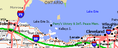
Below is a list of boat launch sites from Toledo to Huron. Each location has ramp photographs and ramp/parking information. Click on the thumbnail photos to enlarge the photograph, and on the website link to go to that ramp's website. This page is intended to be a reference page from the Interactive Map Page Launch Ramps icons. Detailed information is found on the Interactive Map Page under the Launch Ramps icons. We are listing ramps from Toledo east to Huron first. Once we find, visit, and list all these ramps we will expand north of Toledo and east towards Cleveland.
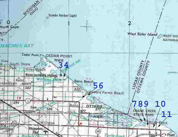
Map 1 - Toledo / Maumee Bay to Davis Besse Nuclear Power Station

1. Saved for Maumee Bay launch not yet photographed.
2. Saved for Maumee Bay launch not yet located (if there is one).
3. Lucas County Cooley Canal launch ramp - on Anchor Point Road off Corduroy Road between Meinke West and Anchor Point marinas. Access Lake through Cooley Canal (same as Meinke Marina below). Website
4. Meinke Marina West - 10955 Corduroy Road, Curtice, OH 43412 419-836-7774 Public ramp is located off Corduroy Road next to big red pole barn, $5 fee. Photos are of Marina entrance and Lake access fuel dock.
5. Saved for launch not yet located (if there is one).
6. Metzger Marsh (Ohio Division of Wildlife) - Bono Road just down from Meinke Marina East. Lake launch ramp, fishing pier, and marsh launch ramp (no Lake access from marsh ramp). website ODW website map
7. Turtle Point Marina - 10275 Lakeview Blvd, Oak Harbor, OH 43449 419-898-2003. Website
 on left of photo, photo coming soon...
8. Lamberjack's Marina - 102_ _ Lakeview Blvd., Oak Harbor, OH 43449 419-898-
 on right of photo, photo coming
soon...
9. Turtle Creek Marina & Campground - 6338 N. Humphrey Road, Oak Harbor, OH 43449 419-898-7745 $5 fee
10. Fenwick Marina & Campground - 10261 W. St. Rt. 2, Oak Harbor, OH 43449 419-898-7009 Winter number 419-898-2405 $5 fee website
11. Wild Wings Marina - 90055 W. St. Rt. 2, Oak Harbor, OH 43449 419-898-1416
Photos coming soon...
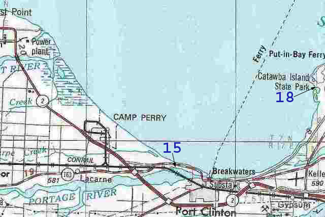
Map 2 - Davis Besse Nuclear Power Station to North End of Catawba Island

12. Toussaint River Marina - coming soon.
13. Beef Creek Marina - coming soon.
14. Brown's Marina Beef Creek - coming soon.
15. Portage River Access (Ohio Division of Wildlife) - Lakeshore Drive about 3/4 mile east of Port Clinton Drawbridge.
16. Saved for launch not yet located (if there is one).
17. Saved for launch not yet located (if there is one).
18. Catawba Island State Park - 4049 E. Moores Dock Road, Port Clinton, OH 43452 419-797-4530 off W. Catawba Rd. at Golf Course website
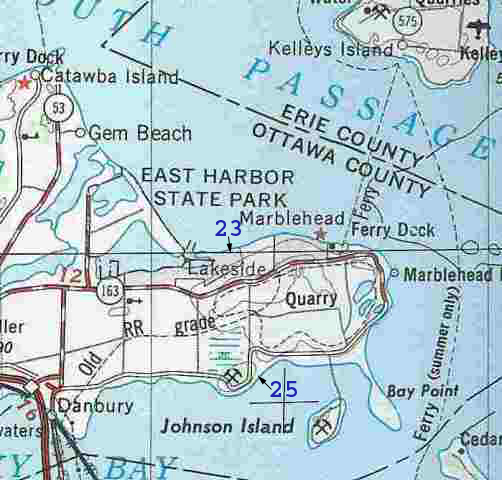
Map 3- Catawba Island East Shoreline and Marblehead Peninsula

19. Saved for launch not yet located (if there is one).
20. Saved for launch not yet located (if there is one).
21. Saved for launch not yet located (if there is one).
22. Saved for launch not yet located (if there is one).
23. Mazurik Access (Ohio Division of Wildlife) - Northshore Blvd. off St. Rt. 163, Marblehead 419-424-5000 website
24. Saved for launch not yet located (if there is one).
25. Dempsey Access (Ohio Division of Wildlife) - Bayshore Road at Hartshorn Road, South shore of Marblehead, 419-424-5000 website
More launch ramps will be added as locations are confirmed and photographs taken.
If you have or know of a ramp that should be added, contact us. Questions or comments are encouraged and may be directed to:
Dave Cremer - Owner, I Lake Erie web site.